

, Limited Series [TV-MA] (6/10)")


")


Tracking the tropics: AM Sept. 25, 2025
FOX 35 Storm Team Meteorologist Brooks Garner gives us a look at the latest updates in the tropics as Hurricane Gabrielle continues to barrel across the Atlantic. Garner is also continuing to monitor Tropical Storm Humberto, previously Invest 93L, and Invest 94L, which has a high chance of development.
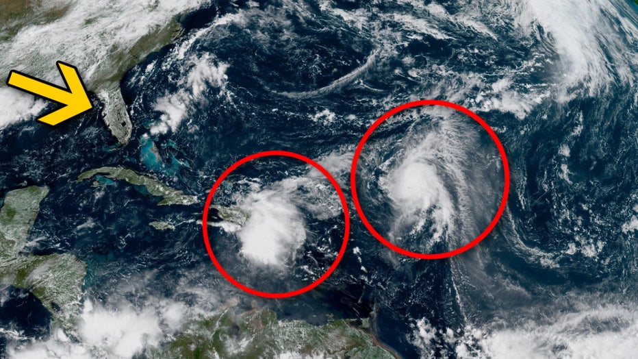
ORLANDO, Fla. – There is a lot going on in the tropical Atlantic right now: Hurricane Gabrielle, Tropical Storm Humberto, and Invest 94L, which is widely expected to become future Tropical Storm Imelda.
Because Tropical Storm Humberto and Invest 94L are seemingly going to be close to one another – though several hundred miles apart, and east of Florida – it brings up questions about the Fujiwhara Effect and how that could impact both storms. Could they merge and become a single, stronger tropical storm or hurricane?
Not exactly. FOX 35 meteorologist Brooks Garner explains what the Fujiwhara Effect, how it could impact Tropical Storm Humberto and Invest 94L, and what it could then mean for Florida’s Atlantic coast.
What is the Fujiwhara Effect?
What we know:
The Fujiwhara Effect happens when two tropical cyclones get close enough to each other to create a shared center, forcing the two storms to whip around that common central point.
If one of the storms is stronger than the other, the effect usually leads to the weaker one being gobbled up by the more powerful cyclone. If the storms are similar in strength, they can sometimes just slingshot around each other and continue on their way.
According to the National Oceanic and Atmospheric Administration (NOAA), the cyclones need to be between 350 and 860 miles of each other to begin rotating around their common center. That distance is dependent on the size of the storms.
Could Tropical Storm Humberto and Invest 94L merge to become one single, powerful storm?
What we know:
Not really, according to FOX 35 meteorologist Brooks Garner.
Tropical cyclones operate in a very specific way — as self-contained heat engines powered by warm ocean water. That unique structure actually makes it meteorologically impossible for two hurricanes to merge into one “super hurricane,” like black holes might in space. If, hypothetically, two vortexes of separate hurricanes collided, they’d disrupt each other’s structure rather than reinforce.
CLICK TO DOWNLOAD THE FOX LOCAL APP
Unlike mid-latitude systems (like cold and warm fronts), which can sometimes absorb remnants of tropical systems, tropical cyclones are conspicuous and distinct entities. When two are near each other, they might interact — even rotate around one another through the Fujiwhara effect — but they don’t combine into a larger storm. In fact, what typically happens is the stronger system disrupts and eventually kills the weaker one.
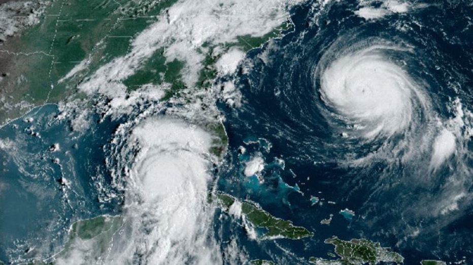
A satellite image of Hurricane Franklin and Hurricane Idalia on Tuesday, August 29, 2023. (Image from the NOAA)
The dominant storm produces subsidence — sinking air on its outer edges — which dries the surrounding atmosphere. That dry air gets drawn into the weaker storm, disrupting its convection and weakening it further. As the weaker storm loses structure and its circulation stretches out (called vorticity elongation), the stronger storm may absorb some of its moisture, but not its strength.
That added moisture might lead to heavier rainfall or a broader rain shield, but it doesn’t make the dominant hurricane any more powerful. Its intensity still depends on ocean heat, not atmospheric moisture alone.
The bottom line is that two hurricanes don’t merge into a superstorm; one usually just neutralizes the other.
Tracking Tropical Storm Humberto and Invest 94L: Spaghetti Models
Why you should care:
The National Hurricane Center (NHC) is now tracking Hurricane Gabrielle, Tropical Storm Humberto and Invest 94L.
A Hurricane Warning has been issued for the Azores as Hurricane Gabrielle continues to barrel across the Atlantic toward the islands and European coastline as a Category 1 hurricane.
Meanwhile, Tropical Storm Humberto is continuing to become better organized as it spins across the Atlantic, and forecasters say it will likely strengthen into a major hurricane (Category 3 or higher) in the coming days.
Lastly, the NHC is continuing to monitor the development of Invest 94L in the Atlantic as forecasters now say there’s a high chance it will become a tropical depression or Tropical Storm Imelda in the coming days. This system could potentially have impacts on the U.S. East Coast.
2025 Atlantic hurricane season
Big picture view:
The peak of the 2025 Atlantic hurricane season was on Sept. 10, but the most active months are typically August, September and October.
SIGN-UP FOR FOX 35’S BREAKING NEWS, DAILY NEWS NEWSLETTERS
The Atlantic hurricane season runs from June through Nov. 30.
The Source: This story was written based on information shared by the FOX 35 Storm Team on Sept. 25, 2025.
, 26 Episodes [TV-Y] (6/10)")